
A severe winter snow drought paired with unusually persistent warm conditions across the Colorado Basin in 2026 has sharply reduced the volume of water flowing into the major reservoirs sustaining the American West. The compounding pressures of climate stress, historic dry spells, and dwindling snowmelt have brought the region’s water infrastructure to a critical juncture, forcing federal managers to take emergency steps to protect vital supplies and hydropower generation.
By the summer of 2026, the sweeping environmental effects of a remarkably weak 2025-2026 mountain snowpack in the Upper Colorado Basin had fully reached Lake Powell. With far less snowmelt than usual feeding the main artery of the Colorado River, inflows dwindled significantly. Consequently, the second-largest reservoir in the United States dropped to record-low levels during the late summer months of August and early September, signaling an alarming escalation in the ongoing crisis across the Southwest.
Lake Powell Falls Below Its Previous Record
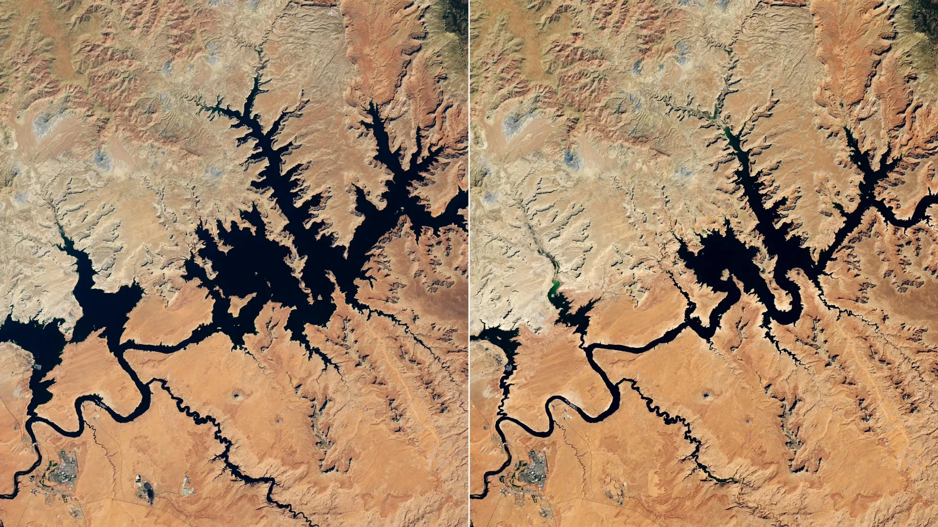
Satellite imagery captured the dramatic environmental change unfolding at Lake Powell near the Glen Canyon Dam. The comparative images were collected by the Operational Land Imager (OLI) aboard the joint NASA-USGS Landsat 8 satellite on September 1, 2017, and September 10, 2026, providing a stark visual record of the retreating water line.
In the September 2026 image, Lake Powell’s water surface elevation stood at 3,517.24 feet. Roughly a month earlier, the vital reservoir had already fallen below its previous historic low of 3,519.92 feet, which had been set just a few years prior on April 13, 2023. Even with the arrival of late summer, water levels continued their relentless decline into early September, leaving vast white bathtub rings of mineral deposits exposed along the canyon walls.
The 2017 satellite image provides a striking contrast to these recent observations, showing Lake Powell during one of its highest water levels recorded over the past decade. The side-by-side comparison highlights the rapid, cumulative loss of storage capacity that has alarmed hydrologists and resource managers alike.
Lake Mead Also Reaches Record Lows
The Colorado River’s complex hydrological journey takes it first into Lake Powell before the water continues downstream toward Lake Mead, the nation’s largest reservoir by volume. Following the trajectory of the upstream crisis, Lake Mead also dropped to unprecedented record-low levels in August 2026, compounding the strain on the entire river system.
The vast Colorado River system is managed cooperatively by the U.S. Bureau of Reclamation (USBR) alongside various state, local, and tribal agencies. It serves as an indispensable lifeline, functioning as a critical source of both municipal water and hydroelectric power across the entire American Southwest. More than 40 million people depend directly on the river’s flow for their daily survival, including residents in major metropolitan centers such as Las Vegas, Phoenix, Los Angeles, and San Diego. Furthermore, the river supplies vital irrigation water to roughly 5 million acres of agricultural land, transforming arid valleys into productive farming regions.
Why Snow Matters So Much to the Colorado River
Much of the vast Colorado Basin is characterized by arid or semi-arid terrain, a fundamental geographic reality that makes mountain snowpack especially vital to the region’s water balance. A substantial share of the Colorado River’s annual flow originates as snow that accumulates at high elevations during the cold winter months and gradually melts during the spring and early summer.
However, the Upper Colorado Basin, alongside many other mountainous regions spanning the U.S. West, received unusually little precipitation in the form of snow during the winter of 2025-2026. This stark shortage amounted to a profound regional snow drought, leaving watersheds dry even before the spring thaw began.
Periods of persistent, record-breaking warmth made these already difficult conditions significantly worse by accelerating the melting process and increasing evaporation rates. As a result, the spring snowmelt delivered far less water to the downstream reservoirs than it normally would under historical averages, providing virtually no meaningful relief for lake levels that were already heavily depleted from years of prior overdraft.
Emergency Steps to Protect Lake Powell
Faced with rapidly diminishing storage and the looming threat of compromised infrastructure, the U.S. Bureau of Reclamation began implementing aggressive emergency measures in April 2026. These steps were designed specifically to stabilize Lake Powell and prevent the reservoir from dropping below the critical elevation threshold required for the continuous generation of hydroelectric power.
Without such immediate intervention, agency models indicated that falling below minimum power pool levels was a realistic and imminent possibility by August 2026, which would have severely disrupted the electrical grid supporting surrounding communities.
To help support and prop up Lake Powell’s dwindling levels, the USBR initiated supplemental water releases from Flaming Gorge Reservoir, located upstream in northern Utah and southern Wyoming. Simultaneously, officials instituted reductions in the volume of water being released from Lake Powell downstream into Lake Mead, shifting the burden of conservation between the two massive storage basins.
To preserve every possible acre-foot of water within the system, the agency also took the difficult step of canceling a "controlled flood" that had been scheduled for April. That managed release was originally intended to rebuild natural sandbars along the river channel, which serve as essential fish habitats. Later in August, officials also skipped a planned "cool mix" release designed to help protect native aquatic species, underscoring the severe trade-offs required to manage a shrinking resource under extreme drought conditions.
A Megadrought Continues to Strain the Southwest
The acute water shortages of 2026 do not exist in a vacuum; rather, they represent the continuation of a severe drought that has persisted across the U.S. Southwest since around the beginning of the 21st century. Climate scientists and hydrologists have increasingly described this prolonged, decades-long dry period as a megadrought, noting that it continues to place intense, unyielding pressure on the region’s limited natural water supplies and fragile ecosystems.
To navigate these compounding challenges, water managers and decision-makers across the Colorado Basin are increasingly turning to advanced technology and monitoring systems supported by NASA to gain more detailed, real-time information about drought conditions and how rapidly they are changing on the ground.
At the headwaters of the Colorado River, for example, a specialized dashboard built around the Western Land Data Assimilation System (WLDAS) provides continuous, real-time visualizations of vital metrics such as soil moisture, snow water equivalent, and evapotranspiration. This high-resolution data helps support Colorado’s dedicated drought task force while also contributing valuable inputs to the weekly updates produced for the U.S. Drought Monitor maps.
Satellite Data Helps Track Drought Across the Basin
Closer to the Lake Powell region, resource managers utilize the Drought Severity Evaluation Tool, which was co-developed in partnership with the Navajo Nation. This platform allows tribal leaders to track localized drought indicators, shifting precipitation patterns, and vegetation health across expansive tribal lands. With ongoing funding provided by NOAA’s National Integrated Drought Information System, the adoption of this evaluation tool successfully expanded in 2025 to include Oklahoma’s Chickasaw and Choctaw Nations.
Another critical resource currently utilized in the region is the Colorado River Integrated Assessment tool, which was developed by researchers at Arizona State University in collaboration with the Central Arizona Project. The system integrates improved climate modeling with measurements of snowpack, surface water and groundwater storage, and soil moisture that have been validated by NASA satellites, bringing comprehensive environmental data together into a single interactive platform for the entire Colorado River Basin.